February 2016
Designing the whaam! style in Mapbox Studio | Mapbox
Inspired by a Roy Lichtenstein original at the Walker Art Center, I decided to design the whaam! map. In his early career, Lichtenstein worked as a comic book artist which inspired his later work. I kept my whaam! style limited to four stylistic mainstays:
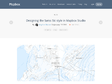
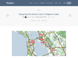
Designing the Swiss Ski style in Mapbox Studio | Mapbox
Swiss maps have long been praised for their accuracy, quality, and beauty. Since 1938 the Swisstopo – Swiss Federal Office of Topography, has been producing maps for hikers, Alpinists, cyclists, planners, tourists, and explorers. I decided to design a ski map with such attention to detail using Mapbox Studio and the Mapbox Streets and Mapbox Terrain tilesets.
May 2015


Improving OpenStreetMap with probe data | Mapbox
We’re building a new data processing pipeline for analyzing GPS probe data streams. This infrastructure will let us improve the map in new ways and at huge scale. Here’s the first look at how it works.
Streaming GPS tracks are overlaid against our streets data, allowing us to identify where there is activity, like people running or driving, but no trail or road data in our map. When we find a place like this, we queue it up for our data team to look at in to-fix, our open source micro-tasking tool. Once we verify that a path or street is missing, we add it to OpenStreetMap and our map is updated in under 10 minutes.
These Pretty City Maps Were Drawn By Our Paths Through Them | Fast Company | Business + Innovation
It’s no secret that tourists love to snap pictures on the Staten Island ferry. Or that photographers will wander the side streets of east London capturing the latest street art. Everyone knows that Paris’s visitor-friendly arrondissements are flooded with selfie sticks on weekends. Now, a new visualization of more than a decade of Flickr photographs shows exactly what paths photographers make when taking pictures.
April 2015

You Can Play Pac-Man On Google Maps Right Now
Go to Google Maps, find yourself an area with lots of roads (New York City will do nicely), and click the big Pac-Man icon
March 2015

Beautiful Destruction: 11 Gorgeous Geologic Maps of Volcanoes | WIRED
(via)IT'S NOT ALWAYS obvious what it is that scientists find beautiful about a graph, microscope slide, soil sample or some other aspect of their work. It just looks like numbers, blobs or dirt to the rest of us. But sometimes a scientific result or product is so visually appealing, anyone would want to hang it on their wall as art.

Tangram Vector map
Proof-of-concept demo of creative cartography using animated vectors to present Open Streetmap data (in this case, heavily inspired by TRON).
David Rumsey Historical Map Collection | The Collection
by 3 othersWelcome to the David Rumsey Map Collection Database and Blog. The Map Database has many viewers and the Blog has numerous categories.

Paula Scher’s Map Paintings Exhibited in New York | New at Pentagram
by 1 otherPentagram is pleased to announce that Paula Scher’s acclaimed map paintings will be presented in a new exhibition opening tonight at the Bryce Wolkowitz Gallery in New York. The exhibition features both paintings and screenprints, including several works that are being shown for the first time, like Scher’s latest painting, Antarctica, pictured above. The show is Scher’s first collaboration with Wolkowitz and remains on view through February 18.


Human Data
by 1 other (via)Human helps people move almost twice as much in six weeks. Every day, people track millions of activities with our app. We visualized 7.5 Million miles of activity in major cities all across the globe to get an insight into Human activity. Walking, running, cycling, and motorized transportation data tell us different stories.
January 2015
Index du site - Visionscarto
« Visionscarto » est un lieu où doivent se sentir à l’aise toutes les personnes qui souhaitent réfléchir sur des concepts originaux de cartographie — comme la cartographie participative, la cartographie radicale ou la cartographie narrative – et de tenter d’en enrichir le champ.
December 2014
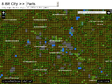
Designing a Super Mario map with Mapbox Studio | Mapbox
Due to the amount of features and level of abstraction, I knew that creating this map would be a great test of my proficiency with Mapbox Studio, as well as Studio's own limits. By diving into the deep end, I learned some useful strategies.
November 2014

GameSetMap | A blog about maps about tennis. Rethinking Sports Analytics for tennis.
GameSetMap is a blog about maps and tennis. In this blog I visually explore and spatially analyze tennis match data to better understand the results and actions during tennis matches. Spatial analytics is reasonably new to tennis, and I hope this blog encourages more when and where statistics about the great game of tennis!
October 2014

September 2014
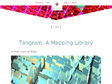
Tangram, A Mapping Library
(via)Traditionally, maps have been expensive and time-consuming to make, but that’s changing fast. High-quality maps are easier to make every day thanks to OpenStreetMap and modern computer graphics capabilities, and we feel they can be pushed even further with ideas and techniques from 3D animation, video games, and other visual disciplines. To test this theory, the Mapzen graphics team has been working on a mapping library called Tangram.

The Audubon Birds & Climate Change Report
(via)Climate change threatens the birds we see every day. I pledge to help build a brighter future for the 314 birds at risk.

Google Unveils The Cartographer, Its Indoor Mapping Backpack | TechCrunch
If you have been following the development of Google Maps over the years, you are probably familiar with the Trekker, the backpack that includes a complete Street View camera setup for mapping anything from hikes into the Grand Canyon to walks through penguin colonies in Antarctica. Today, a new backpack is joining Google’s mapping tools: the Cartographer for indoor mapping.
July 2014

Google’s Street View cameras are touring museums and taking weird selfies by accident - Quartz
The curtain slips a bit in the Camera in the Mirror, a new Tumblr project by the Spanish artist Mario Santamaría that collects accidental self-portraits of Google’s hulking cameras while they go about their work. It turns out that museums have a lot of mirrors, and the cameras often photograph themselves in front of them.
+
June 2014

Je bouge donc je suis : bienvenue dans l'ère de la géographie 2.0 - L'actu Médias / Net - Télérama.fr
(via)Rappelez-vous. Vos années collège, les cours de géo, la barbe épaisse de monsieur Brunet. Les ressources agricoles de la Chine ; le Mont Gerbier de Jonc ; la variabilité climatique dans le delta du Nil. Interminable randonnée au pays de l'ennui… ? En 2014, plus aucune raison de bâiller. La géographie est (re)devenue excitante. Vivante ! Inter-active ! Ludique !
En savoir plus sur http://www.telerama.fr/medias/je-bouge-donc-je-suis-bienvenue-dans-l-ere-de-la-geographie-2-0,113754.php#qYRxjskUOpFEVEtD.99
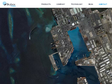
Skybox Imaging - Welcome
We empower global businesses to make better decisions with timely, high fidelity imagery and infinite analytics. Work with us in one of three ways.

Skybox Imaging - Skybox Imaging + Google
We’re thrilled to announce that Skybox Imaging has entered into an agreement to be acquired by Google!
Five years ago, we began the Skybox journey to revolutionize access to information about the changes happening across the surface of the Earth.
We’ve made great strides in the pursuit of that vision.
We’ve built and launched the world’s smallest high-resolution imaging satellite, which collects beautiful and useful images and video every day. We have built an incredible team and empowered them to push the state-of-the-art in imaging to new heights. The time is right to join a company who can challenge us to think even bigger and bolder, and who can support us in accelerating our ambitious vision.