2008
Système d'Information Géographique (SIG) ____Un blog de Référence sur la Géolocalistion opensource, Système d'Information Géographique
Un blog de Référence sur la Géolocalistion opensource, Système d'Information Géographique (SIG)
2007
Meteosun____Prévisions météo/Semaine___basé sur Google maps
basé sur Google maps, ce site vous permet de connaître les prévisions météo de la région de votre choix sur une semaine.
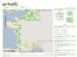
V-trafic____donne le trafic autoroutier. Basé sur Google maps
by 13 otherscomme sont nom l’indique, vous donne le trafic autoroutier. Basé sur Google maps, il est extrêmement complet (possibilité d’afficher les accidents, travaux, fermetures, conditions météos, web cam disponibles etc) et complètement paramétrable :
RenaLId__Tout sur la cartographie online, la géolocalisation, les médias localisés, les mashups (Google Maps et autres APIs)
by 1 otherTout sur la cartographie online, la géolocalisation, les médias localisés, les mashups (Google Maps et autres APIs)
FlashEarth : nouveaux layers_______RenaLId ::
Vous connaissez peut-être déjà Flash Earth, une application en Flash produit par Paul Neave proposant les tuiles de Google Maps et Microsoft Virtual Earth. Flash Earth offre désormais de nouveaux layers “satellites/aériens” en plus : - Yahoo Maps

Flashearth____________tout simplement une vision nouvelle de Google Maps et Msn Virtual Earth..
by 64 otherstout simplement une vision nouvelle de Google Maps et Msn Virtual Earth... Très pratique et facile d'utilisation !!
2006
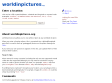
worldinpictures.org____Flickr geotagging application
by 1 otherallows you to view photos taken at any worldwide location. When you enter a location above, this is converted into a latitude/longitude pair which is used to look up "geotagged" photos on the photo sharing site Flickr. If you want your own pictures to app
loc.alize.us – Explore your world through everyone's eyes ___Bookmarklet Flickr extention
by 1 otherA smart way to browse and locate Flickr images on large map of the world. Filter photos by selecting a specific tag or searching for your buddy's user name. All navigation is done without any page refresh. An app that may save your boring afternoons. pro

MAKE: Blog: HOW TO GPS Tag Photos: Flickr, Mappr, Google Earth....
by 12 othersHOW TO GPS Tag Photos: Flickr, Mappr, Google Earth....
1
(10 marks)
