2008
Modest Maps
by 4 othersModest Maps is a BSD-licensed display and interaction library for tile-based maps in Flash (ActionScript 2.0 and ActionScript 3.0) and Python.
Our intent is to provide a minimal, extensible, customizable, and free display library for discriminating designers and developers who want to use interactive maps in their own projects. Modest Maps provides a core set of features in a tight, clean package, with plenty of hooks for additional functionality.
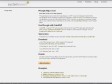
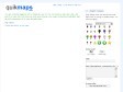
Des cartes réseaux comme chez Free
Vous êtes admiratifs des cartes réseaux proposées sur le site de l’opérateur pour afficher en temps (presque) réel l’état de leurs liaisons ? Vous voulez faire la même chose chez vous ? Alors ce tutorial est fait pour vous…
Nous allons pour cela utiliser le logiciel open-source WeatherMap4RRD. Ce dernier peut produire des cartes de ce type:
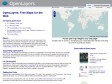
Home of the Geotag Icon Project
by 3 others (via)The Geotag Icon is intended as a web "standard" icon for identifying geotagged content to humans.
The advent of inexpensive GPS devices and free tools like Google Maps or Flickr Map mean that more and more people are associating their content (typically blog posts or photos) with a specific geographic location. Such "geotagging" stores coordinates within metadata or microformat tags—where machines can find them but people can't.
That's where the Geotag Icon comes in. It provides a visual reference to a map link, or if no link is yet made helps viewers recognize the geographic relevance of the content.
It's free, easy to use and helps us all visualize the developing semantic web.
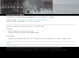
Scott Jehl, Designer/Developer, Boston, MA | Process: StyleMap v2: Visual Sitemap
by 1 other (via)StyleMap v2 uses valid HTML, CSS and a touch of DOM scripting to produce a visual sitemap out of an unordered list (UL). The result is a functional, scalable, and above-all rapid way to produce a tree-style map for the planning stages of your project.
Keep in mind that although we'll cover the details of how the sitemap works, in practice you'll only need to worry about changing the markup to match your website structure. The CSS and Javascript can then be added as they are and will take care of the rest!
2007
Google Maps PHP Class: Phoogle Maps | systemsevendesigns Freelance Web Development Cornelius, NC
by 8 others (via)Phoogle Maps (pronounced like Foogle Maps) is a PHP class that integrates itself with the Google Maps API and with the Google Geocoding API to make an easy to use interface to display Google Maps on your site. With about 5 lines of PHP code you can display a customized Google Map on your website. Please note that you will need a free Google Maps API Key to use Phoogle Maps
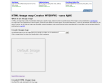
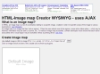
HTML-Image map Creator WYSIWYG - uses AJAX
by 4 others (via)ever needed to do an image map?!? here it is a simple online image map creator :)
The website works on:
[Linux] Browsers with Gecko-Engine (Mozilla, Netscape 6+, Galeon), Konqueror, Netscape 4, Opera 5, 6 and 7.
[Windows] Gecko-Browsers, IE 4, 5 and 6, Netscape 4, Opera 5, 6 and 7.
[Mac] Safari, Gecko-Browsers, Opera, Netscape 4, partially IE.
This HTML image maps creator is made using: Prototype, JavaScript Vectorgraphics Library, dp.SyntaxHighlighter, YUI Reset CSS, YUI Fonts CSS, Scriptaculous
2006
DIY Map: Create clickable maps in Flash
by 2 others (via)
Voici peut être quelque chose de plus interessant. Que diriez vous d'une carte en flash, zoomable, clicable et paramétrée via un fichier externe en xml ? C'est sympa et à mon avis, il est assez facile d'en faire ce que l'on veut alors amis codeurs, faites nous de jolies cartes...
OpenLayers: Home
by 3 others
OpenLayers makes it easy to put a dynamic map in any web page. It can display map tiles and markers loaded from any source. MetaCarta developed the initial version of OpenLayers and gave it to the public to further the use of geographic information of all kinds. OpenLayers is completely free, Open Source JavaScript, released under the BSD License.
2005
Actions Réseaux Numériques : Action Carto Pour Wikini
(via)
intégrer une carte éditable dans wikini: faire correspondre une position enregistrée sur une image à une page du wiki.
1
(12 marks)
