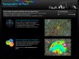
public marks

PUBLIC MARKS from philippej with tags maps & géographie

May 2009

January 2009

File:Communes of France.png - Wikipedia, the free encyclopedia

(via)
Instructif et impressionnant. Une version SVG serait en effet bienvenue.

November 2008

Boundaries

(via)
Paris délimité par les utilisateurs de Flickr. Forcément un peu différent de la réalité ;)

philippej's TAGS related to tag maps

3d +   api +   apllication +   bookmarklet +   carte +   cartographie +   data +   earth +   economie +   Environnement +   flickr +   geographie +   géographie +   google +   gps +   GPX +   graphiques +   histoire +   humour +   image +   information +   javascript +   kml +   metro +   microformats +   mobile +   mobilité +   navigation +   économie +   osm +   outils +   paris +   photo +   photos +   php +   politique +   pratique +   qrcode +   rss +   société +   sport +   statistiques +   svg +   tags +   tutoriels +   url +   video +   visualisation +   visualisations +   web +   weblogue +   wiki +