2010
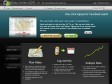
Ride with GPS
(via)"... a recreational route sharing community for cyclists, motorcyclists, runners, hikers, mountain bikers, and anyone else who is involved in a route-oriented sport."
Un des nombreux outils en ligne permettant de tracer un parcours d'après une carte Google Maps. Petit + : l'élévation des tracés à l'air assez précise.
2009
Calcul d'itinéraire (jogging, footing, course à pied, vélo...)
by 1 other"... permet de calculer la distance totale, ainsi que le dénivelé, d'un parcours sportif effectué (jogging, footing, course à pied, vélo, roller...) en plaçant des points sur la carte."
2007
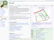
OpenStreetMap
by 2 others« OpenStreetMap is a project aimed squarely at creating and providing free geographic data such as street maps to anyone who wants them. »
2006

Life of a Geolocated Blog Post
by 1 other (via)« View entire photo sets as self-contained KMZ files in Google Maps »
1
(4 marks)