2009
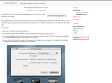
Finally, Geoencoding in Lightroom! Announcing my GPS-Support Plugin
A plugin for Adobe Lightroom, “Jeffrey's GPS Support”, that adds support for Geoencoding photos from within Lightroom
Géolocalisation dans iPhoto '09
Il ne manque plus que l'ingestion d'un fichier de traces GPS pour localisation automatique et ce sera bien. La même chose dans Lightroom, ce serait top !
2008
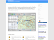
cGPSmapper - Your Tool For Creating Maps
cGpsMapper makes it possible to create vector maps which can be uploaded to Garmin GPS receivers.
GPSPhotoLinker: Overview
GPSPhotoLinker can be used to save location and GPS position data to a photo. The latitude and longitude recorded by your GPS unit while you were taking photos can be linked, and saved, to the photos. GPSPhotoLinker automatically enters the city, state...
Fish-Track » KMLToGPX Converter 2.0 Released
Convert kml files to gpx on your desktop with the KMLTOGPX converter software.
myTracks
myTracks is a Mac OS X 10.5 application for the ambitious hobby photographer. The main idea of myTracks is the handling of GPS tracks and their relations to photos taken during the track
GPS-Info CMM - Display and use GPS coordinates embedded in photos directly in the Finder
GPS-Info CMM is a Contextual Menu Module designed for Mac OS X that displays the GPS coordinates of a photo file, and allows you to view that location in Google Earth, Flickr, Panoramio, Google Maps, or MapQuest.
Apple - Downloads - Math
A utility for uploading, downloading, and transcoding GPS data among GPS devices, GPX files, and KML files (for Google Earth). The resulting files can be used in a variety of applications available for the Macintosh, including TrackRunner, TrailRunner, and of course Google Earth.
locr - locate your photos
With the free locr PC software, you are able to geotag photos automatically and simultaneously. All you need is a GPS-datalogger and the locr GPS Photo for Windows software.
GeoSetter for Windows
GeoSetter is a freeware tool for Windows for showing and changing geo data of image files (e.g. images taken by digital cameras).
G p s P a s S i o n
by 1 otherLe géocodage de photos consiste à ajouter une position GPS (latitude/longitude) à une photo pour mémoriser l'endroit exact où elle a été prise
2007
HoudahGeo - Geocoding for the Mac
HoudahGeo may operate in a fully automatic mode when provided a track log file from a GPS receiver. Finer control is possible by attaching photos to waypoints created using a GPS device.

MacBook-fr - [GPS] Garmin apporte la compatibilité avec le Mac
Garmin a développé des pilotes sous MacOS X pour la gestion de certains de leurs GPS, notamment la gestion des POI
TrailRunner
(via)TrailRunner is a route planning software for all kinds of long distance sports like running, biking, hiking, inline-skating, skiing and more. If you ever asked yourself how long your workout routes are and what route you should choose for this evening — then TrailRunner should be your training-partner.
scriptaMac.at - GPS Automator Actions
A set of Automator Actions to download, upload and convert GPS routes, waypoints and tracks.
LoadMyTracks
by 1 other (via)LoadMyTracks is a piece of software that will communicate with GPS devices from many manufacturers to send and receive data. It can also be used to translate data between the popular GPX and KML (Google Earth) formats. The software provides support for Waypoints (single locations in space), Routes (lists of waypoints that can be used as instructions of where to go, Tracks (the breadcrumbs that many GPS devices keep to show where you have been) and additional data that may vary by device.
scriptaMac.at - Software
(via)The GeoTagging Automator Action automatically tags your images with geographical coordinates and elevation data from a GPS track file. It supports a great range of image formats, including many raw image formats like Canon CR2, Nikon NEF and Adobe DNG.
GPSBabel 1.3.2 – Mac OS X – VersionTracker
(via)GPSBabel converts waypoints, tracks, and routes from one format to another, whether that format is a common mapping format like Delorme, Streets and Trips, or even a serial upload or download to a GPS unit such as those from Garmin and Magellan. By flatting the Tower of Babel that the authors of various programs for manipulating GPS data have imposed upon us, it returns to us the ability to freely move our own waypoint data between the programs and hardware we choose to use.
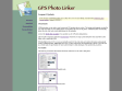
GPSPhotoLinker: Overview
by 4 othersGPSPhotoLinker can be used to save location and GPS position data to a photo. The latitude and longitude recorded by your GPS unit while you were taking photos can be linked, and saved, to the photos. GPSPhotoLinker automatically enters the city, state, and country annotations into the metadata.
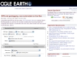
Ogle Earth: GPS and geotagging, now automated on the Mac
GPS Automator Actions by Austria's Sigurd Buchberger lets you use Mac OS X's built-in scripting tool to download data from connected GPS devices, convert that to KML and many other formats, and also upload to GPS devices.

PhotoGPSEditor 1.0 - MacUpdate
PhotoGPSEditor is an easy to use meta-data editor for JPEG (photo) files, plus it can match data from GPS (gpx) files.
1
(24 marks)
