2017
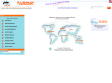
ONLINE TOOLS - SEARCH - Locate My Name
Locate My Name will help you find distribution of names across countries and regions.
The site mainly focuses on surnames, because more people with the same surname in a place, means something: either those people are in the region since long ago and the name originates from there or nearby, or members of the same family for some reason relocated there.
We also have information for first names, but this this is mainly used for entertainment and curiosity and it has no historical value.
To start with a surname, choose a country from the right or use the search function. If you are interested in firstnames, check the list here.
2010
Coupe Fédérale de Distance - C.F.D. - PARAPENTE - FFVL.FR
Liste/Recits de vols * Les derniers vols * Liste de tous les vols * Sélectionner les vols à visualiser * Liste des récits de vols (carNet) * Ajouter un récit à un vol (avec photos !) * Ajouter une trace GPS à un vol
2009

[OSM] Évaluer rapidement une distance sur une carte (Open Street Map) - 26 août 2009
Un outil simple et efficace pour calculer une distance.
[OSM] CORINE Land Cover,base de données géographique,Recense l'occupation des sols sur toute l'Europe....
CORINE Land Cover, c'est une base de données géographique qui recense l'occupation des sols sur toute l'Europe. La résolution est de 20 mètres et la dernière version de ces données date de 2006.Les données Corine Land Cover peuvent être affichées dans l’outil Google Earth.
Devenez modélisateur 3D pour Google - KORBEN
Google vient de sortir un outil qui permet à tous de modéliser en 3D les batiments sur Google Map / Google Earth. En gros, vous allez pouvoir vous "amuser" en sélectionnant le batiment de votre choix, l'entourer avec une forme de cube (ou autre formes 3D) et dès que vous êtes satisfait, hop, y'a plus qu'à exporter ! Votre modèle sera alors sauvegardé dans Google 3D Warehouse et intégré par la suite dans Google Earth ! Franchement, j'admire ! Google a trouvé une solution encore moins chère que de sous traiter en Inde ou en Chine la modélisation 3D de Google Earth et en plus, vous allez trouver ça fun !

Recherche d’emplois en bibliothèque – par zone géographique
1. BibliofranceSilvère l’avait mentionné dans son billet sur Bibliofrance : une carte de France des offres d’emplois publiée sur Bibliofrance est disponible 2. BiblioemploisBiblioemplois, qui a été créé lors de la fermeture de Biblio-fr pour proposer une solution (au moins transitoire) à la disparition de Jobilise,3. Bibliofrance + Biblioemplois 3. Bibliofrance + Biblioemplois Et bien évidemment, la fusion des deux sources (Bibliofrance + Biblioemplois) sur une carte unique (par simple fusion de deux pipes) est peut-être encore plus intéressante Voici le résultat (sur Google Maps) La même carte sur Yahoo Rq 1 : Google Maps a tant d’informations à afficher qu’il ne peut le faire pour la carte de France entière : il vous faut zoomer sur votre région pour voir apparaître toutes les annonces de votre zone.
2008
Instantly Locate Yourself on Google Maps
Instantly Locate Yourself on Google Maps Firefox with Greasemonkey (All platforms): The Google Maps & Geode Greasemonkey user script adds a small Current Position link next to the Google Maps search box that instantly locates you on a map using Firefox's new geolocation technology. To use this script right now, you'll need to install the previously mentioned Geode Firefox extension—but as soon as Greasemonkey supports Firefox 3.1, which itself supports geolocation natively, you won't need any extra extensions. Since so many Google Maps searches start at your current location, whether you're getting directions or looking for nearby businesses, this quick link cuts out the work of entering in your address each time. Handy!
2007
Convertir vos traces GPS vers Google EarthLa France vue du ciel / Survol de France : Photos aériennes de France
Convertir vos traces (aux format standards IGC, NMEA, trk (PCX5) et les logs GPS Bluetooth der PDA RoyalTek Bluetek RBT3000) en trace Google Earth, avec moulinette .Donne points de départs et d'arrivée , Altitude et vitesse, Altitude et vitesse max.
FlashEarth : nouveaux layers_______RenaLId ::
Vous connaissez peut-être déjà Flash Earth, une application en Flash produit par Paul Neave proposant les tuiles de Google Maps et Microsoft Virtual Earth. Flash Earth offre désormais de nouveaux layers “satellites/aériens” en plus : - Yahoo Maps

Flashearth____________tout simplement une vision nouvelle de Google Maps et Msn Virtual Earth..
by 64 otherstout simplement une vision nouvelle de Google Maps et Msn Virtual Earth... Très pratique et facile d'utilisation !!
Find your cell phone with Google Maps' click-to-call
Next time you misplace your cell phone and don't have another phone on hand to call it with, do what reader Aaron does: take advantage of the new, free click-to call feature in Google Maps and let them call you.
2006
Spell words with buildings
At one time or another, most of us have wondered how our name would look if it was spelled out with buildings that look like letters when viewed from above. Finally... finally!... we can do just that. Head to geoGreeting, type in your name (or any word or
loc.alize.us – Explore your world through everyone's eyes ___Bookmarklet Flickr extention
by 1 otherA smart way to browse and locate Flickr images on large map of the world. Filter photos by selecting a specific tag or searching for your buddy's user name. All navigation is done without any page refresh. An app that may save your boring afternoons. pro
Visited Countries
by 13 othersVisited Countries Visited Countries is a small project demonstrating the power of manipulating the palette of a gif image on the fly. Here we start with a map of the world with each country in a different color. The script asks which country you have been
MAKE: Blog: HOW TO GPS Tag Photos: Flickr, Mappr, Google Earth....
by 12 othersHOW TO GPS Tag Photos: Flickr, Mappr, Google Earth....
2005
Delicious Mind Map Maker
by 22 othersThis program will make a Clustered Mind Map out of your delicious entries and add the map to the list. Source Code. You need to have java installed to view the map with your browser... but it is worth. Please do not abuse of this facility. New posts on th

GMiF - (Google Maps in Flickr)_+_del.icio.us Flickr Contacts_+_LfVr -(a Lightweight flickr )ViewerYuan.CC Web Experiments
by 7 othersThere's an easy way to see your geotagged photos on Gmap without leaving flickr. Just install the greasemonkey script to your firefox and see your photos shown on map right away. There will be a button added at the right-most of button bar if the photo is
Ted's Mozilla page - Google Maps Live
by 1 otherAllows you to feed latitude/longitude data to Google Maps and have it tracked in realtime
1
(22 marks)
