February 2006
Graphviz - Graph Visualization Software
by 15 others (via)Graph visualization is a way of representing structural information as diagrams of abstract graphs and networks. Automatic graph drawing has many important applications in software engineering, database and web design, networking, and in visual interfaces for many other domains.
November 2005

Flade - Flash Dynamics Engine
by 5 others (via)Flade (Flash Dynamics Engine) is an open source actionscript 2.0 library for simulating 2D physics using Verlet integration. It currently features rectangular, circular, & wheel primitives, spring & angular constraints, and surfaces composed of line segments, circles, & rectangles. It's designed primarily for games with a goal of speed and ease of use, and is MTASC -strict compatible.
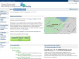
Geoserver : open gateway for geospatial data
Geoserver is a fully functional open source WFS-T and WMS server that follows the OGC open standards.
With Geoserver you can publish data as maps/images (using the WMS), as actual data (using the WFS), and allow users to update, delete, and insert features (using the WFS-T). GeoServer's focus is ease of use and support for open standards, in order to enable anyone to quickly share their geospatial information in an interoperable way. More information on specific features of GeoServer can be found here .
October 2005

1
(5 marks)