2012

2008
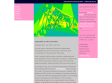
Tim's Quicktime VR Panoramas : QTVR
@timpatterson picked a digital camera, an inexpensive Fuji FinePix A205, and decided to get back to creating Quicktime VR panoramas for fun and he has a Google Map of all my QTVR locations in Austin!
Skyhook Wireless
Si vous trouvez qu'il est difficile de trouver où vous êtes avec la recherche automatique proposée par votre iPhone ou iPod Touch, vous pouvez maintenant référencer de nouveaux hotspots WiFi, à commencer par le(s) votre(s) !

Mapnik C /Python GIS Toolkit | Welcome
Mapnik is a Free Toolkit for developing mapping applications. Above all Mapnik is about making beautiful maps. It is easily extensible and suitable for both desktop and web development.
2007
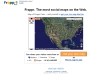
GPS Visualizer
GPS Visualizer is a free, easy-to-use online utility that creates maps and profiles from GPS data (tracks and waypoints), street addresses, or simple coordinates.

2006


mapguide: MapGuide Open Source
MapGuide Open Source is a web-based platform that enables users to quickly develop and deploy web mapping applications and geospatial web services. MapGuide features an interactive viewer that includes support for feature selection, property inspection, map tips, and operations such as buffer, select within, and measure. MapGuide includes an XML database for managing content, and supports most popular geospatial file formats, databases, and standards. MapGuide can be deployed on Linux or Windows, supports Apache and IIS web servers, and offers extensive PHP, .NET, Java, and JavaScript APIs for application development. MapGuide Open Source is licensed under the LGPL.


MP:Blog - Yahoo Maps v3 veröffentlicht
Nachdem diverse Map-Anbieter ihre Satelliten Karten in Deutschland auf den Weg gebracht haben zieht nun auch Yahoo Maps nach.
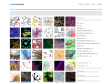
Greenwich Emotion Map - Christian Nold
participatory workshops that invite people to borrow a Bio Mapping device and go for a walk. The device measures the wearer's Galvanic Skin Response (GSR), which is an indicator of emotional arousal in conjunction with their geographical location.


2005
1970

1
(25 marks)


