2008

LLOW - Languages of the World - LanguageServer - University of Graz
The LLOW-database is work in progress and this version is restricted to what you see and what you get. The ultimate aim is to arrive at an extensive description of all languages of the world on the basis of linguistic-genetic (language families, clusters, ...) and sociolinguistic (status as official language, minority language, ...) criteria as well as social-, geopolitical and geographical parameters (number of speakers, geographical extension, ...). In addition to this literature references, internet-links, short texts on the individual language families and groups as well as text- and audio samples of individual languages will be offered.
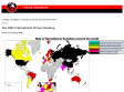
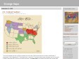
Leading surveillance societies in the EU and the World 2007
Map of surveillance societeies around the world
2007
The DIMES project
What does the Internet look like? How does it evolve?
DIMES is a distributed scientific research project, aimed to study the structure and topology of the Internet, with the help of a volunteer community (similar in spirit to projects such as SETI@Home).
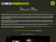
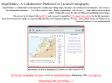
Chris Harrison - Internet Map: City-to-City Connections
by 1 otherThe Dimes Project provides several excellent data sets that describe the structure of the Internet. Using their most recent city edges data (Feb 2007), I created a set of visualizations that display how cities across the globe are interconnected (by router configuration and not physical backbone). In total, there are 89,344 connections.
The first rendering displays the relative densities of Internet connectivity across the globe. The stronger the contrast, the more connectivity there is. It is immediately obvious, for example, that North America and Europe are considerably more connected than Africa or South America. However, it is important to note that this only reflect density of connections, and not usage. Hundreds of people may utilize a single connection in an internet cafe, often the only form of connectivity people have access to in developing nations.
Additionally, three graphs showing network connections were created. I should note this is not the first time graphs like this have been created - I've seen dozens of variations, most being practical in nature (e.g. cable locations, bandwidth). I decided to pursue an aesthetic approach - one more visually intriguing and interesting to explore than useful. The intensity of edge contrast reflects the number of connections between the two points. No country borders or geographic features are shown. However, it should be fairly easy to orient yourself.
Note: No projection has been applied to the geographical data. Latitudes and Longitudes were rounded to the nearest whole number and used in a flat coordinate system. This means that the planetary surface area represented by each point varies, skewing how the data (and densities - both point and edge) is shown!
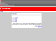
CARTOME
Cartome, a companion site to Cryptome, is an archive of news and spatial / geographic documents on privacy, cryptography, dual-use technologies, national security and intelligence -- communicated by imagery systems: cartography, photography, photogrammetry, steganography, camouflage, maps, images, drawings, charts, diagrams, IMINT and their reverse-panopticon and counter-deception potential. (seems not maintained anymore however)

HapMap
the International HapMap Project is a partnership of scientists and funding agencies from Canada, China, Japan, Nigeria, the United Kingdom and the United States to develop a public resource that will help researchers find genes associated with human disease and response to pharmaceuticals.
2006
geopium
Geopium.org est un site d'information et de publication relatif aux problématiques de la géopolitique des drogues illicites en Asie. Il sert la diffusion de l'information géographique en proposant des ressources documentaires pour la recherche en sciences humaines, sociales et politiques.
2005
mapomatix
MapOMatix is a collaborative environment for creating and editing maps, the maps can contain physical elements ( oil resources, telecomunication antennas, ... ) as well as abstract ones ( human organisations, web servers, ... ) and relations between these entities. Behind this tool is the idea of editing and publishing tactical maps.
1
(9 marks)
