2009

2007
Generic Mapping Tools (GMT) pour tracer des cartes sous Ubuntu - KubuntuBlog
by 2 othersGMT (Generic Mapping Tools) est une collection d'outils libres et multi-plateformes permettant la génération de cartes et de diagrammes. Regroupant de l'ordre de 60 programmes en ligne de commande elle offre de nombreuses possibilités telles la création de cartes selon différentes projections, la représentation de données géographiques, la génération de graphiques et même la représentation en 3D.

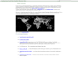
Worldmapper: The world as you've never seen it before
by 5 othersWorldmapper is a collection of world maps, where territories are re-sized on each map according to the subject of interest.

3Liz - Démocratisons les Systèmes d'Information Géographique
(via)Le but de l'équipe 3Liz est de fournir une boîte à outils permettant de concevoir des logiciels de SIG (Systèmes d'Information Géographique) de manière simple et rapide.
Cette boîte à outils (ou toolkit), MozMapTK , est un projet OpenSource basé sur le navigateur Internet Mozilla Firefox.
2006
About Geo-Names
(via)The geonames.org geographical database is available for download free of charge under a creative commons attribution license. It contains over eight million geographical names and consists of 6.2 million unique features whereof 2.2 million populated places and 1.8 million alternate names. All features are categorized into one out of nine feature classes and further subcategorized into one out of 645 feature codes.
The data is accessible free of charge through a number of webservices and a daily database export.
Geonames is integrating geographical data such as names, altitude, population and others from various sources. All lat/long coordinates are in WGS84 (World Geodetic System 1984). Users may manually edit, correct and add new names using a user friendly wiki interface.
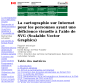
La cartographie pour déficients visuels - La cartographie sur Internet pour les personnes ayant une déficience visuelle à l'aide de SVG (Scalable Vector Graphics)
by 3 othersLa cartographie sur Internet pour les personnes ayant une déficience visuelle à l'aide de SVG (Scalable Vector Graphics)
ISO 3166-1 - Wikipedia, the free encyclopedia
by 1 otherISO 3166-1, as part of the ISO 3166 standard, provides codes for the names of countries and dependent areas.
Version XML/RDF/OWL du COG
L'INSEE, Mondeca et Dyomedeaannoncent la publication du Code Officiel Géographique (COG) sous une forme utilisant les technologies XML, RDF et OWL.
Données géographiques RDF
by 2 othersL'Insee publie dans cette section des données issues du code officiel géographique (COG) modélisées selon le standard RDF du web sémantique. Pour plus d’information sur le web sémantique, on se reportera au site du W3C consacré à cette activité.
InternetActu.net » Where 2.0 : une synthèse
(via)A l’heure ou le Geoportail de l’Institut géographique national devient enfin accessible, il nous semblait intéressant de revenir sur la conférence Where 2.0 qui a eu lieu mi-juin à San José Californie, consacrée aux outils et aux enjeux de la géolocalisation.
NASA World Wind
by 32 others (via)World Wind lets you zoom from satellite altitude into any place on Earth. Leveraging Landsat satellite imagery and Shuttle Radar Topography Mission data, World Wind lets you experience Earth terrain in visually rich 3D, just as if you were really there.
CIA World DataBank II
(via)The CIA World DataBank II is a collection of world map data, consisting of vector descriptions of land outlines, rivers, and political boundaries. It was created by the U.S. government in the 1980s.
2004


Cybergeo Home Page
From the Local to the Global, a Geography without Limits
1
(18 marks)