2012

2010
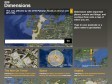
BBC - Dimensions
Dimensions is an experimental prototype for the BBC. We want to bring home the human scale of events and places in history.
2009
2008
2007
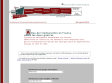
Fonds de cartes pour l'enseignement de la géographie
Des fonds de cartes en formats vectoriels pour les enseignants
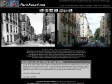
ParisAvant.com
Découvrir Paris par des clichés pris il y a une centaine d'années, confrontés à des photos récentes. Toutes les photos sont également situées sur google maps
2005
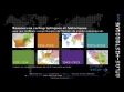
Atlas de l'immigration
Atlas de l'immigration en France. Entre les deux guerres
Système de cartographie automatique sur Internet.
3888 cartes en couleurs et 144 tableaux à votre disposition pour décrire la distribution territoriale des étrangers dans les départements français en 1931 et 1936.
ATLAS HISTORIQUE - Cartographie & histoire
L'histoire du monde contemporain (de 1815 à nos jours) en cartes.
1
(11 marks)


