2013

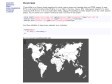
jQuery Mapael
jQuery Mapael is a jQuery plugin based on raphael.js that allows you to display dynamic vector maps.
For example, with Mapael, you can display a map of the world with clickable countries. You can build simple dataviz by setting some parameters in order to automatically set a color to each area of your map and generate the legend. Moreover, you can plot cities on a map with their latitude and longitude.
2012

jVectorMap
jVectorMap is a jQuery plugin employed to show vector maps and visualize data on HTML pages. It uses SVG in all modern browsers like Firefox 3 or 4, Safari, Chrome, Opera, IE9, while legacy support for older versions of IE from 6 to 8 is provided with VML. Using jVectorMap is pretty simple as for any other jQuery plugin.

2011

2010

2009
2008
2007
jQMaps by SeViR
jQMaps est un plugin jQuery permettant d'ajouter très facilement des cartes Google Maps avec différents points d'intérêt
2006

2005
1
(18 marks)


